


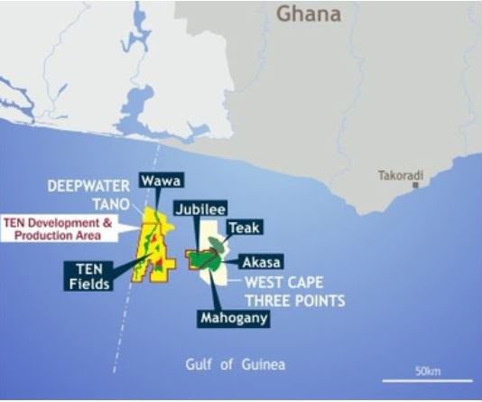
The Ghana National Petroleum Corporation (GNPC) is examining a hub-based development model for stranded and marginal petroleum resources in the Tano Basin, using geospatial analysis to determine whether shared infrastructure can make otherwise difficult-to-develop oil and gas resources commercially viable.
The approach comes as Ghana seeks to reverse declining petroleum production and maximise value from existing resources without committing the high capital costs associated with developing every discovery as a standalone project.
Rather than treating each field or discovery as an independent development, GNPC is assessing how multiple resources could be aggregated around common production infrastructure, potentially allowing several fields to share facilities, transportation routes and other critical assets.
The Corporation believes such an approach could reduce upfront capital requirements and improve the economics of resources that may not justify dedicated infrastructure on their own.
Turning Stranded Resources Into Commercial Opportunities
The Tano Basin assessment is being supported by Geographic Information System (GIS) technology, which allows GNPC to combine information on petroleum resources, existing infrastructure and possible development routes with environmental and surface-level data.
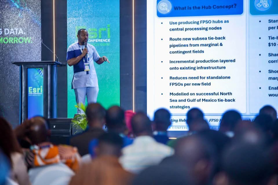
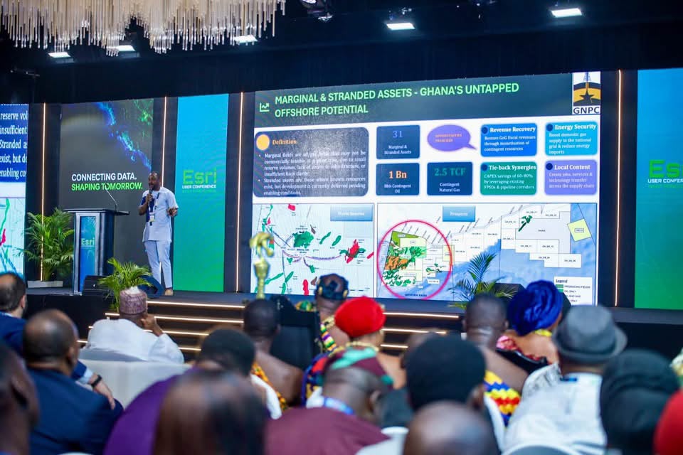
Presenting the work at the Esri User Conference West Africa 2026 in Accra, GNPC Senior Geomatic Engineer, Emmanuel Boadum Donkor, said the assessment covers potential resources in the basin containing more than one billion barrels of oil and about 2.5 trillion cubic feet of gas.
The figures, however, represent resources associated with development opportunities currently under assessment. They are not new discoveries and do not constitute approved additions to Ghana’s petroleum reserves or production.
Their eventual contribution to national output would depend on further technical and commercial evaluation, regulatory approvals and the ability to secure the investment required to develop the resources.
That distinction is important because Ghana’s production challenge is not simply one of identifying hydrocarbons. The more difficult question is whether those resources can be developed at a cost that supports commercial production.
The hub concept attempts to address precisely that problem.
“If you take up the CAPEX in terms of developing the infrastructure to extract these stranded resources independently, if you compare it to doing it in the hub way which we are seeking to do, you realise that it brings down the cost of investment and then it actually boosts our confidence to be able to extract these stranded resources,”
GNPC Senior Geomatic Engineer, Emmanuel Boadum Donkor
The economics of shared infrastructure could therefore become as important as the size of the underlying resource.
A discovery may contain commercially attractive volumes but still remain undeveloped if the cost of building dedicated pipelines, processing facilities, subsea infrastructure or other production systems is too high relative to expected returns.
A hub-based system changes that equation by spreading infrastructure costs across several potential developments.
Infrastructure Sharing Could Reduce Development Costs
For Ghana, the relevance of the model extends beyond the Tano Basin.
The country already has established petroleum infrastructure and producing assets, creating opportunities to consider tie-ins and other forms of shared development rather than constructing entirely new systems for every marginal resource.
The assessment is therefore examining the relationship between resource location and infrastructure availability.

GIS technology allows technical teams to map those relationships and compare alternative development scenarios before major investment decisions are made.
Potential infrastructure routes can be examined alongside environmental sensitivities, settlements and other physical constraints, giving planners a broader view of the costs and risks associated with different development options.
This is particularly important in offshore petroleum development, where infrastructure decisions can involve substantial capital commitments and long project timelines.
A development model that reduces duplication could improve the likelihood that smaller or marginal resources are brought into production.
It could also allow discoveries that would otherwise remain stranded to contribute to Ghana’s petroleum system incrementally.
However, infrastructure sharing is not automatically commercially viable.
The fields involved must have compatible production profiles, sufficient combined volumes and development timelines that justify the shared investment. Technical compatibility, ownership arrangements, tariff structures and the allocation of operating costs would also need to be addressed.
The hub model therefore provides a development pathway rather than a guarantee that the resources will ultimately be produced.
Geospatial Intelligence Strengthens Petroleum Planning
The work also demonstrates the increasingly strategic role of digital technology in Ghana’s petroleum sector.
According to Mr Donkor, a significant proportion of GNPC’s technical information has a spatial component. That makes GIS useful as a common platform through which different technical teams can analyse and interpret information.
For petroleum development, location determines much more than where a discovery is situated.
It influences infrastructure routing, environmental exposure, proximity to existing facilities, access to transportation systems and the potential cost of connecting a resource to markets.
By bringing these datasets together, GNPC can compare development alternatives before committing substantial resources to engineering and construction.
The approach also allows the Corporation to move from evaluating individual assets towards examining the petroleum system as an interconnected network.
That shift could become increasingly important as Ghana’s producing fields mature and the industry looks for ways to sustain production from smaller discoveries and undeveloped resources.
Digital Tools Support Broader Production Strategy
GNPC’s use of GIS forms part of a wider push towards digitalisation within its petroleum activities.
The Corporation is exploring the integration of geospatial technology with artificial intelligence, remote sensing, real-time data and digital twins to improve planning, asset monitoring and operational decision-making.
Earlier in 2026, GNPC received the Esri Special Achievement in GIS Award for its application of GIS in evaluating pipeline routing options linked to the potential commercialisation of stranded and marginal offshore resources.
These tools could become increasingly relevant as Ghana attempts to make better use of its existing petroleum resource base.
The central challenge is not necessarily the absence of resources, but the cost and complexity of converting those resources into sustained production.
Digital modelling can help narrow that gap by allowing technical teams to identify infrastructure configurations that offer better economic outcomes before physical investment begins.
Tano Basin Development Still Requires Investment
The Tano Basin initiative remains at the assessment stage, meaning the resources identified in the analysis should not yet be interpreted as imminent additions to Ghana’s production.
Further technical studies will be required to establish the quality, recoverability and development potential of the resources, while commercial assessments will determine whether the proposed infrastructure arrangements can generate acceptable returns.
Regulatory and investment approvals would also be necessary before any development moves forward.
Nevertheless, the hub-based concept offers a potentially important route for Ghana as it confronts declining production from mature assets.
Developing every stranded or marginal resource independently could make many projects economically difficult.
Aggregating resources around shared infrastructure could distribute capital costs across a larger production base and improve the economics of developments that might otherwise remain dormant.
For Ghana, that could mean extracting greater value from resources already identified rather than relying exclusively on major new discoveries to restore production growth.
The success of the approach will ultimately depend on whether GNPC can translate its geospatial assessments into commercially bankable projects.
If it can, the Tano Basin could become an example of how infrastructure sharing, digital planning and coordinated field development can be used to unlock resources that have remained outside Ghana’s production system because of cost and infrastructure constraints.
The immediate significance, therefore, lies not in declaring a new oil or gas find, but in changing how Ghana evaluates the resources it already has.
READ ALSO: Ghana Secures Enhanced Labour Deal for Nurses in Saint Kitts and Nevis